Our Services
Synergizing Technology and Innovation in a Sustainable Future
Learn MoreBIM Services
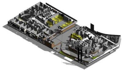
BIM coordination, or Building Information Modeling coordination, is a collaborative process that involves the integration and management of digital information for a construction project. BIM is a 3D modeling technology that allows architects, engineers, contractors, and other stakeholders to create and share detailed digital representations of a building or infrastructure project. BIM coordination focuses on ensuring that these digital models from various disciplines are compatible and can be effectively integrated to streamline the construction process. Janus has been awarded ISO 19650 Building Information Modelling (BIM) certification, which recognizes our commitment to excellence in Building Information Modeling (BIM) and digital construction processes.
BIM Coordination
BIM coordination, or Building Information Modeling coordination, is a collaborative process that involves the integration and management of digital information for a construction project. BIM is a 3D modeling technology that allows architects, engineers, contractors, and other stakeholders to create and share detailed digital representations of a building or infrastructure project. BIM coordination focuses on ensuring that these digital models from various disciplines are compatible and can be effectively integrated to streamline the construction process.
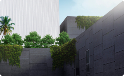
Rendering & Animation
We deliver exceptional rendering and animation services tailored to the needs of the built environment.
With a keen eye for detail and advanced technology, we bring architectural designs to life through stunning visualizations and immersive animations. Unlock the full potential of your projects with our professional expertise and elevate your vision to new heights.
BIM Training
We offer comprehensive BIM training programs designed to empower industry practitioners with the knowledge and skills needed to excel in the ever-evolving world of building information modeling. Through hands-on workshops and interactive courses, we equip professionals with the expertise to streamline workflows, enhance collaboration, and optimize project outcomes.

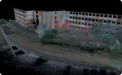
Reality Capture
Our reality capture service is dedicated to providing high-quality scanning solutions for the built environment. Whether it’s capturing progress at different stages or conducting comprehensive completion scans, we utilize cutting-edge technology and techniques to deliver accurate and detailed representations. Trust us to capture reality with precision and efficiency, enabling better decision-making and project management.
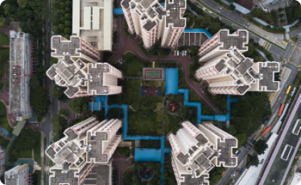
Drone Photogrammetry
Our drone photogrammetry service is tailored to the built environment, offering a powerful and efficient solution for capturing detailed aerial imagery and generating accurate 3D models. With state-of-the-art drones and advanced photogrammetry techniques, we provide high-resolution data for site analysis, mapping, and visualization, empowering better decision-making and project planning.
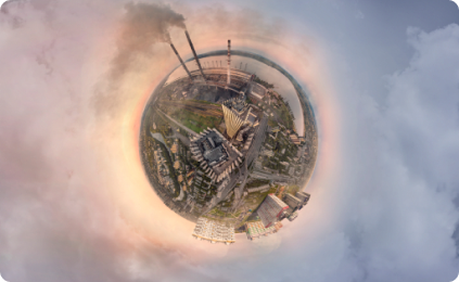
360 Scanning
we provide a comprehensive and immersive solution for capturing detailed visualizations. Using advanced camera technology, we create high-resolution 360-degree images that allow for virtual tours, interactive exploration, and accurate documentation of spaces. Experience the full view of your project with our cutting-edge scanning service.
Laser Scanning
Our high-precision laser scanning service is aimed at delivering accurate and detailed data for engineering design purposes in the built environment. With state-of-the-art laser scanning technology, we capture precise measurements and intricate details, enabling informed decision-making, efficient design workflows, and precise project execution. Trust us to provide the data you need for engineering excellence.
Our Service Scope
BIM Services
BIM coordination, or Building Information Modeling coordination, is a collaborative process that involves the integration and management of digital information for a construction project. BIM is a 3D modeling technology that allows architects, engineers, contractors, and other stakeholders to create and share detailed digital representations of a building or infrastructure project. BIM coordination focuses on ensuring that these digital models from various disciplines are compatible and can be effectively integrated to streamline the construction process.
Janus has been awarded ISO 19650 Building Information Modelling (BIM) certification, which recognizes our commitment to excellence in Building Information Modeling (BIM) and digital construction processes.
BIM Expertise
BIM coordination, or Building Information Modeling coordination, is a collaborative process that involves the integration and management of digital information for a construction project. BIM is a 3D modeling technology that allows architects, engineers, contractors, and other stakeholders to create and share detailed digital representations of a building or infrastructure project. BIM coordination focuses on ensuring that these digital models from various disciplines are compatible and can be effectively integrated to streamline the construction process.
Rendering & Animation
We deliver exceptional rendering and animation services tailored to the needs of the built environment.
With a keen eye for detail and advanced technology, we bring architectural designs to life through stunning visualizations and immersive animations. Unlock the full potential of your projects with our professional expertise and elevate your vision to new heights.
BIM Training
We offer comprehensive BIM training programs designed to empower industry practitioners with the knowledge and skills needed to excel in the ever-evolving world of building information modeling. Through hands-on workshops and interactive courses, we equip professionals with the expertise to streamline workflows, enhance collaboration, and optimize project outcomes.
Reality Capture
Our reality capture service is dedicated to providing high-quality scanning solutions for the built environment. Whether it’s capturing progress at different stages or conducting comprehensive completion scans, we utilize cutting-edge technology and techniques to deliver accurate and detailed representations. Trust us to capture reality with precision and efficiency, enabling better decision-making and project management.
Drone Photogrammetry
Our drone photogrammetry service is tailored to the built environment, offering a powerful and efficient solution for capturing detailed aerial imagery and generating accurate 3D models. With state-of-the-art drones and advanced photogrammetry techniques, we provide high-resolution data for site analysis, mapping, and visualization, empowering better decision-making and project planning.
360 Scanning
we provide a comprehensive and immersive solution for capturing detailed visualizations. Using advanced camera technology, we create high-resolution 360-degree images that allow for virtual tours, interactive exploration, and accurate documentation of spaces. Experience the full view of your project with our cutting-edge scanning service.
Laser Scanning
Our high-precision laser scanning service is aimed at delivering accurate and detailed data for engineering design purposes in the built environment. With state-of-the-art laser scanning technology, we capture precise measurements and intricate details, enabling informed decision-making, efficient design workflows, and precise project execution. Trust us to provide the data you need for engineering excellence.
Our Services


